![]() Of the thousands of things that can be purchased with a stolen credit card number, an airline ticket has to be the world’s stupidest choice. So today’s Darwin Award goes to Ashley Issa, whose final destination will be quite different from the one she booked on Expedia.
Of the thousands of things that can be purchased with a stolen credit card number, an airline ticket has to be the world’s stupidest choice. So today’s Darwin Award goes to Ashley Issa, whose final destination will be quite different from the one she booked on Expedia.
Archive | August, 2010


Ashley Issa Moron
L’Oratorie Saint Joseph Non Fini?
 Maybe they ran out of money, or vision. Or maybe the workers went on strike and never came back. For whatever reason, the interior of St. Joseph’s Oratory in Montreal doesn’t stand up to the grandeur of its exterior. It almost seems incomplete. Like they ran out of resources after finishing the facade and just threw up a concrete interior to get the job done.
You can certainly imagine that the builders ran out of materials, because St. Joseph’s is huge; larger than either Notre-Dame de Paris or St. Pauls Cathedral in London. But somehow, it feels smaller. When stepping into the gothic halls of Notre-Dame, one’s senses are overwhelmed. You just can’t process everything there is to see. It is a bit staggering and awe inspiring. St. Joseph’s is nothing like that.
Getting into the basilica involves ascending several escalators that could just as easily connect floors in an office building. The chapel itself is cavernous, but non-descript. Unadorned concrete pillars support a plain vaulted ceiling, which together hold up a similarly muted dome.
But outside is a different story. The rising slope of Mount Royal adds to St. Joseph’s impressive height; vaulting its magnificent dome, second in size only to St. Peter’s in Rome, to the highest point in all of Montreal. The Italian Renaissance style façade is gorgeous, evoking comparisons to Florence’s Duomo. Formal gardens in front, and an interesting prayer garden to the left, complement and complete the basilica’s external opulence.
If you’re in Montreal, certainly stop by St. Joseph’s for the grounds and to admire the Oratory’s external architecture. Step inside for the price: it’s free.

The stark interior of St. Joseph's Oratory doesn't match the grandeur of its exterior
A Virtual Stroll In Montreal
As with just about everything recently, we’ve had to adapt our style of travel to the realities of living in an RV. In the past, we would land in a city, pick up a map, and stroll around to get our bearings. We’d always feel helplessly lost at first, but within a couple of hours we usually owned the city. We’d know what could be done reasonably on foot, where we’d want to take the metro to, and what might require a taxi. We’d also have a strong sense of which things on our to-do list should be grouped together.
But now we don’t have a city hotel room to retreat back to after our stroll. If we want to explore the city, we have to get there first, and even that takes some degree of planning. Do we drive in or take public transportation? Where is the best place to park for what we want to do? In what order should we do things? All this, and more, has to be decided before we’ve even set foot in town.
Thankfully, Google has this neat feature where you can plot destinations on an interactive map. This allows us to visualize our itinerary for Montreal, and capture some of the benefits of our stroll virtually. For example, we know we want to catch a free jazz concert on Thursday night, but we don’t know what else on our itinerary made sense to do the same day. After plotting a bunch of ideas on Google Maps, we can easily see what else is in the neighborhood. The “walking directions” feature tells us that a walk from Notre Dame, to the Archaeology Museum, to Marie-Reine-du-Monde Basilica to the Jazz venue takes about 40 minutes; a pretty good day’s itinerary. More importantly, it tells us that the botanical gardens and the Jean-Talon Market are probably too far to walk, and too much of a pain for the metro. So we’re grouping them together and driving.
You can play around with our map here, to see how it works and maybe create something similar for your own next trip. In the future, we’ll be plotting more of our itineraries this way to get a feel of a city’s geography, if not its culture, before we arrive.
The Sisterhood Of The Traveling Plant

The strength of Shannon’s empathy for this plant is so great that one could rightly mistake her for a Druid (unless, of course, they were also aware of her notoriously black thumb). For years, though, this hardy little plant has managed to not only resist her finger of death but also routine snacking by our first cat, Emma. It is a remarkable survivor.
Uncertain how the plant would fare in the RV, Shannon considered entrusting its care to her mother while we were on the road. In the end, Shannon decided to take it with us. And it was good. Sunlight has done remarkable things for our spindly little friend, and it has thrived during our three months of travel. But now, as we prepare to make way for the Canadian border, we are certain there is one thing this plant will not survive: customs. Either when crossing this way or that, some douchey customs agent will declare this little plant a dire national threat and, for the sake of God fearing Canadians or Americans everywhere, will do their heroic duty and have it destroyed. Of this, we have no doubt.
Fortunately, we are close enough to relatives who kindly agreed to act as “plant sitters” while we don berets in le Canada Français. Of course retrieving said plant upon our return will require a two hour round trip drive and a $25 ferry ride. Such is the burden of vagabonds who become attached to things.
An Interesting Trail

Shannon scales Sterling Pond Trail
That’s all it took. Shannon noticed an interesting-looking trail, and moments later we had parked the car and were scrambling up rocky steps to who knew what.
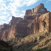
We actually had no intention of hiking that afternoon. Our plans only included a scenic drive through Smuggler’s Notch on our way back from a short stop in Stowe, Vermont. The Notch is a winding 2,16- foot crag cleaved in Sterling Mountain. Breathtaking views of rocky cliff walls and mountain waterfalls can be seen while threading your car through the bolder-strewn switch backs of what is now Route 108. But if you’re lucky enough to have an eagle-eyed girl in the passenger seat, you can also see the trail head to Sterling Pond leading up the mountainside.
 Sterling Pond trail ended up being more of a climb than a hike, with a 1,500-foot elevation gain over the 1.1 mile path. That’s basically like walking a flight of stairs from 14th Street in New York City to the top of the Empire State Building on 34th Street, plus a couple hundred feet. We felt surprisingly good on the ascent, though. Maybe these hikes are starting to undo the years of entropy that had turned us into large bags of jelly. One can only hope.
The actual hike was the most interesting we’ve been on during this trip. Much of the trail is a shallow brook that bubbled around rocks and over our feet as we made our way up the mountain. Countless tiny waterfalls sprang from nearby rocks and cascaded across our path. At the top, a large flat rock at the tip of Sterling Pond offered a welcome place to take in the stunning views and catch some sun–and our breath.


Meet Brian and Shannon

Fulltime wanderers since 2010, Brian & Shannon are traveling the world on a quest to see everything there is to see . . . at least once.
Travel Reading:


Top Posts & Pages